The Manor of Kingsbury
A summary, prepared with his invaluable help, of the talk given by David Dean to the AGM of the Society of St Michael's and Kingsbury on 21 November, 2006
The position and history of Kingsbury
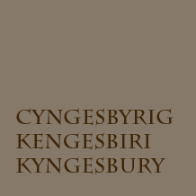
David Dean, a local historian and good friend of the Society, opened his talk with a slide showing variations in the spelling of Kingsbury to be found in the early documents: Cyngesbyrig, Kengesbiri and Kyngesbury.
They are to be found in the monastic chronicles which draw together parchments, hand written by monks during the middle ages, about people, localities and events. The chronicles were sorted and printed on the order of the Master of Rolls in 1857. Copies of local interest, written in Latin, may be seen in the main reference section of St Albans County Library.
Sometimes the monk's account was from personal observation, though this did not preclude bias, showing events in a favourable light or downright fabrication. Some writings were based upon the stories of credulous and superstitious informants. Some parchments were dated, others not, which made the later compilation of histories somewhat suspect. Copying records from one monastery to another could require memorising the contents and several days travel. Errors accumulated over the centuries and many of the original accounts were lost or destroyed. As a result, the surviving documents contain both gems and fiction and should be read with this in mind.
The story about Canute sitting on the beach and telling the incoming tide to stop, so widely repeated, originates from the hand of a single monk.
It is from the monastic chronicles that we first read about Kingsbury. The information almost certainly comes from Saxon monks, summarised by Matthew Paris (d 1259) in his Lives of the Abbots and reaching us as part of Gesta Abbatum. We read that Kingsbury was a royal foundation; that the inhabitants farmed a great fish pool; that considerable animosity existed between this community and the monastery; that at some point closest to the monastery there existed a propugnaculum or bulwark, apparently part of its fortification.
The chronicles further inform us that to discourage Royal and expensive visitors to the monastery, keen on boating on the River Ver and the fishpool, the abbot, Alfric I, purchased the fishpool from King Edgar (959-75) and drained it. Abbot Ealdred attempted to control the robbers and whores of Kingsbury (monastic perception). The 8th Abbot, Eadmer, set about destroying the remains of the old Roman town of Verulamium, stockpiling the materials thus made available. Alfric II, who had been chancellor to King Ethelred (979-1016), bought Kingsbury from the king and levelled the royal mansion except for the propugnaculum - bulwark or gate house. He subjugated the remaining inhabitants. Page in the Victoria County History thought that the actions attributed to Alfric I and Alfric II were in fact by Alfric II.
In 1152, King Stephen was persuaded to allow the demolition of the Kingsbury bulwark. Kingsbury was ploughed and sown, but the name was retained.
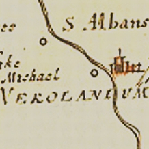
Precisely where Kingsbury was located, when established and by whom, is unknown. Matthew Paris gives us little idea, though he thought that Fishpool Street lay above the banks of the fish-pool, which, he wrote, were still visible in his time. Strangely, he appears to ignore the survival of lands as a monastic manor.
A notion that the nucleus and fortification of Kingsbury had been upon the large mound bounded by Fishpool Street (and now by Verulam Road and New England playing field), was suggested by Salmon in 1728. "This Castle ftood low by the Side of the Fifh-pool, and hath no Traces of Fortification, unlefs a Part of a Mole which feems to have encompaffed it;..." By the late 19th century this fiction was generally accepted and supported by numerous observations and histories. It was thought by some that the sharp bend in Fishpool Street was caused by negotiating the propugnaculum or fortified bulwark of Kingsbury. However, in 1869 it was alternatively suggested that the street had earlier lacked the sharp bend and had run straight across the southern side of the monastery to Holywell Hill, a theory restated by Professor Martin Biddle about twenty five years ago. It was in the early 1980s that Chris Saunders publicly expressed doubt concerning the identification of the Kingsbury mound, though general acceptance of this view took some years.
Of the extensive lands which once supported Kingsbury, little is known. Both before and after the dissolution, parts of the manor were sold off, including the site of St Michael's church, part of the mound behind Fishpool Street and what is now Victoria playing field. A few weeks after giving the talk David Dean identified land behind the King Harry Public House which had been held copyhold of the manor.
In 1156/57, two charters of Pope Adrian IV referred to the local churches of St. Peter and St. Stephen but named St. Michael's as the Church of Kingsbury. The church was still referred to as 'of' (or 'at') Kingsbury until at least the 15th century although its dedication to St Michael was also used.
Modern historians and archaeologists like Dr Rosalind Niblett, Chris Saunders and David Dean have come to the view that it is likely that Kingsbury was situated to the west of Fishpool Street, and that Verulamium was the heart of Saxon Kingsbury. Some of the factors that have led them to this view come from linkages between what has been referred to above:
- the accounts of the Abbots' efforts to quell the local inhabitants,
- and to destroy and loot the Roman town,
- the reference to the Church of Kingsbury which is in St.Michael's village
as well as
- the position of the early Saxon graveyard (near King Harry Lane),
- the positions of Kingsbury Manor and various ancient roads.
Martin Biddle suggested that Fishpool Street originally went south of the Abbey because the Saxon market was probably to the south of the Abbey. The bend in Fishpool Street was a diversion created when the market moved to the north and was not caused by the presence of a gatehouse to Kingsbury. Ros Niblet's persuasive argument is that it is likely that the gatehouse referred to in the manuscripts was the London Gate to Verulamium.
The New England playing field was owned by Grove Lowe, who was the first to dig the Roman Theatre. The New England site was then steeper and included pits which Lowe hoped would be investigated by the then St Albans Council, to which he gave the land. Unfortunately the pits were simply filled in. Salmon (1728) said that there were no signs of fortifications in the land to the north of Fishpool Street.
The function and extent of Kingsbury Manor
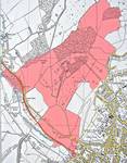
- Click to enlarge

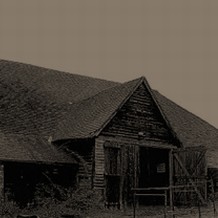
The existence of the watermill is recorded in the Domesday Book and the Manor and the two Barns (14th and 17th Century constructions) behind it were a source of funds for the monastery. Kingsbury manorial court records survive from the 13th century and courts met until at least the late 19th century. The mid 17th century manor is shown superimposed upon an Ordinance Survey map of the 1930s. David speculated on the antiquity of some of its boundaries which can still be identified in the modern landscape. The grounds of the manor extended well to the north of what is now Verulam Road and beyond Batchwood. Batchwood is covered with hornbeam trees, used for making charcoal, and contains some apparently ancient hedgerows which would be worth investigating, particularly along a north-western boundary to the Manor. Part of the eastern boundary could well have been marked by Everlasting Lane, the steep rise in which could have been avoided if it had not been required to skirt an edge to the Manor lands. The western edge was probably close to what is now the Gorhambury Estate.
At the time of the dissolution Kingsbury Manor was purchased by John Cox, who sold it on to the Wendy family. It was not, as is sometimes assumed, purchased by Ralph Rowlatt and then the Bacon family as part of the Gorhambury estate.
The Back Road, which ran along the north side of the Barns, went on to be the south-western boundary of the Manor. The road included a hundred metre ford along the Ver before swinging northwards to follow the line of what is now the Redbourn Road - before, of course, the creation of Verulam Road and its connection.
The course of the River Ver has been modified over the years especially to maintain a good flow of water for the mills.
Watling Street and the du Prey Nunnery
The Back Road was not Watling Street. The course of the latter went through what is now the entrance to the Roman Theatre and Gorhambury estate. The du Prey nunnery and leper hospital was situated between what is now the entrance from Bluehouse Hill and Gorhambury House. The nunnery was originally on the south side of what has become the Gorhambury Drive which was re-routed in the early 19th century so that the farm, which contained traces of the nunnery church, then stood to the north.
David Dean, November 2006